ILLUSTRATED HUMOR MAP
Regions of Santa Monica
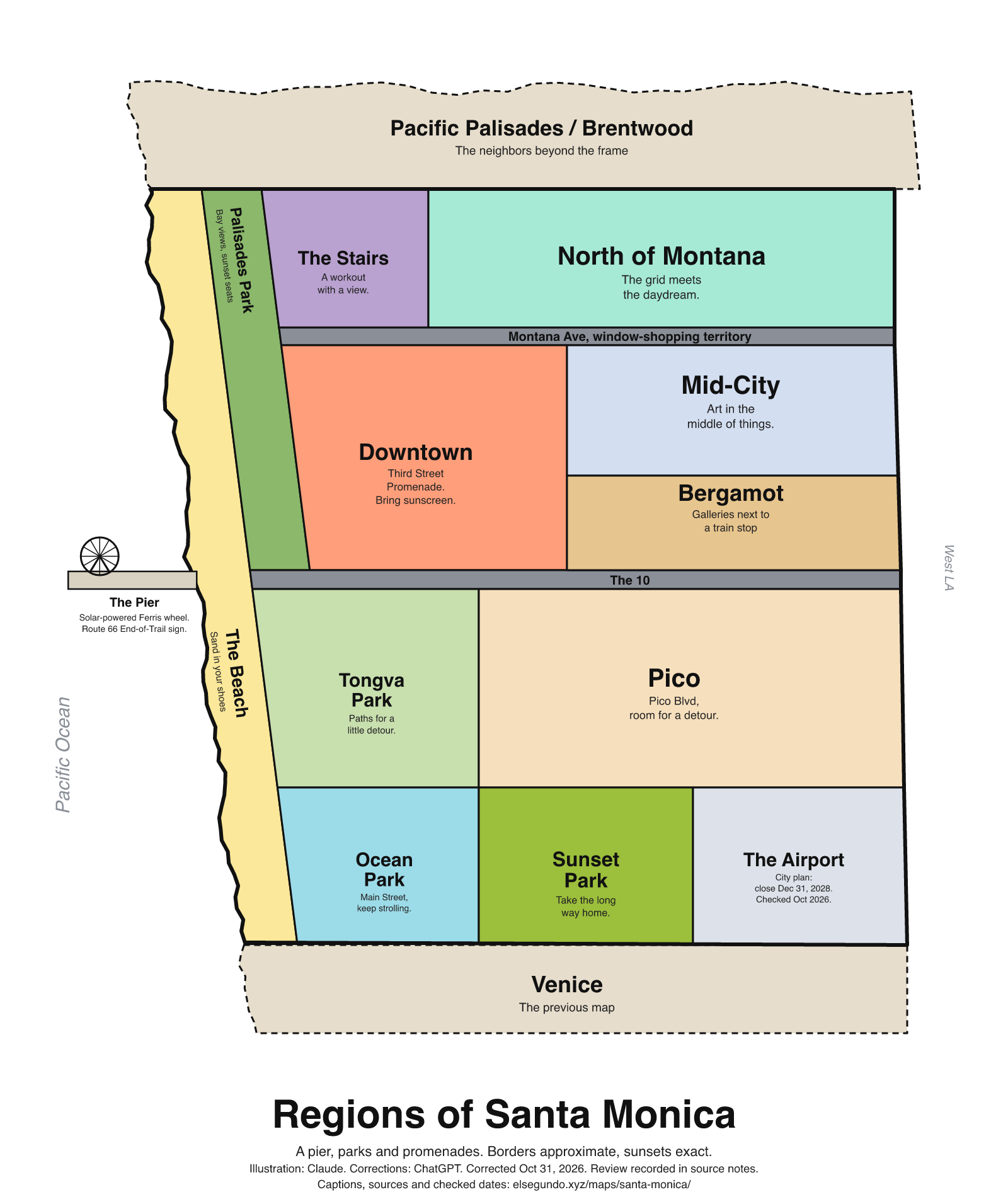
A schematic drawing with jokes about places. The colored regions are editorial choices, not surveyed boundaries or official neighborhood definitions.
How to read this drawing
Editorial region sketch, not a boundary or navigation map. The coast is west; the Pier and downtown connect to the coastal area; Bergamot is drawn north of I-10, with Pico south of I-10. Neighborhood names are supported by city GIS and the destination bureau; the illustrated polygons are not official neighborhood boundaries. Airport text describes a city plan, not a completed closure.
Labels are schematic. Use an operator's current map for directions and check current access, hours and conditions before visiting.
Every caption, in readable text
This transcript includes the labels, jokes, neighboring places and title printed in the artwork.
- The Pier
- Solar-powered Ferris wheel.
- Route 66 End-of-Trail sign.
- Pacific Palisades / Brentwood — The neighbors beyond the frame
- The Beach — Sand in your shoes
- Palisades Park — Bay views, sunset seats
- The Stairs — A workout with a view.
- North of Montana — The grid meets the daydream.
- Montana Ave, window-shopping territory
- Downtown — Third Street Promenade. Bring sunscreen.
- Mid-City — Art in the middle of things.
- The 10
- Tongva Park — Paths for a little detour.
- Pico — Pico Blvd, room for a detour.
- Bergamot — Galleries next to a train stop
- Ocean Park — Main Street, keep strolling.
- Sunset Park — Take the long way home.
- The Airport — City plan: close Dec 31, 2028. Checked Oct 2026.
- Venice — The previous map
- Pacific Ocean
- West LA
- Regions of Santa Monica
- A pier, parks and promenades. Borders approximate, sunsets exact.
- Illustration: Claude. Corrections: ChatGPT. Corrected Oct 31, 2026. Review recorded in source notes.
- Captions, sources and checked dates: elsegundo.xyz/maps/santa-monica/
Facts behind the captions
Factual labels and layout notes are documented below. The jokes are editorial wording; they do not establish measurements, operating status or visitor access.
- The Pier: solar-powered Ferris wheel. [sm-pier-wheel]
- The Pier has a Route 66 End-of-Trail sign. [sm-pier-sign]
- The Beach label identifies Santa Monica State Beach; “Sand in your shoes” is editorial humor. [sm-beach]
- Palisades Park has Santa Monica Bay views; “sunset seats” is an editorial phrase, not a reservation or availability promise. [sm-palisades]
- Santa Monica stairs are a fitness landmark; “A workout with a view” is a qualitative caption, without a step count or jurisdiction claim. [sm-stairs]
- North of Montana, Ocean Park, Pico, Mid-City and Sunset Park are city-recognized neighborhood organization names. Their drawn boundaries are editorial. [sm-gis-north] [sm-gis-ocean] [sm-gis-pico] [sm-gis-mid] [sm-gis-sunset]
- Montana Avenue is a shopping street; Main Street is another shopping corridor. No precise length is claimed. [sm-tour-shopping]
- Downtown includes the Third Street Promenade. [sm-tour-downtown]
- Mid-City has an arts scene, and Pico Boulevard supplies the Pico label. [sm-tour-pico-art]
- Tongva Park has walking paths. [sm-tongva]
- Bergamot Station Arts Center has galleries and an adjacent rail station. [sm-bergamot-station] [sm-bergamot-gallery]
- Pico is south of I-10; the city describes the connection across I-10 to Bergamot. [sm-pico-bergamot]
- In its September 26, 2025 statement, the city reaffirmed a plan to close Santa Monica Airport at the end of December 31, 2028. The caption does not report a completed closure. [sm-airport-plan]
Santa Monica Pier [sm-pier-sign]
“End of the Trail” sign
Santa Monica Pier [sm-pier-wheel]
solar-powered Ferris wheel
Santa Monica Travel & Tourism [sm-tour-shopping]
shopping tour on Main Street or up Montana Avenue
Santa Monica Travel & Tourism [sm-tour-pico-art]
Pico Boulevard, discover Mid-City’s arts scene
Santa Monica Travel & Tourism [sm-tour-downtown]
Downtown Santa Monica / Third Street Promenade
City of Santa Monica [sm-palisades]
views of the Santa Monica Bay
City of Santa Monica [sm-tongva]
There are walking paths throughout the park
Santa Monica Travel & Tourism [sm-stairs]
Santa Monica stairs, an iconic wooden staircase often used for fitness
Santa Monica Travel & Tourism [sm-beach]
Santa Monica State Beach
City of Santa Monica [sm-gis-sunset]
Friends of Sunset Park
City of Santa Monica [sm-gis-north]
North of Montana Association
City of Santa Monica [sm-gis-ocean]
Ocean Park Association
City of Santa Monica [sm-gis-pico]
Pico Neighborhood Association
City of Santa Monica [sm-gis-mid]
Santa Monica Mid-City Neighbors
Bergamot Station Arts Center [sm-bergamot-station]
the adjacent 26th Street/Bergamot stop situated at the North end of Bergamot Station Arts Center
Bergamot Station Arts Center [sm-bergamot-gallery]
GALLERIES + VENUES
City of Santa Monica [sm-pico-bergamot]
between the Pico Neighborhood south of the 10 Freeway and the Bergamot Area
City of Santa Monica [sm-airport-plan]
permanently close the Santa Monica Airport at midnight on December 31, 2028
About this version
Artwork and initial captions: Claude (Anthropic). Corrections and source notes: ChatGPT/Codex (OpenAI). Checked by: GPT-6 Astra (OpenAI), ChatGPT/Codex (OpenAI; independent geometry review). Publication authorized by Michael Hoydich. Completed review: .
Review scope: Technical source-guide, accessible-transcript and schematic-layout checks. Independent source authentication sampled primary pages and retained official GIS/map records; it did not re-authenticate every source or establish surveyed boundaries or current visitor access.
- Corrected October 31, 2026 (Los Angeles): Moved Bergamot north of I-10. Removed the unsupported stair count and geographic-endpoint claims; the airport closure is labeled as a dated City plan.
- Added a complete readable transcript, source excerpts with actual fetch dates, and a schematic-layout explanation. Sources do not establish current visitor access, hours or availability.
Captions, sources and provenance as JSON · Report a correction