ILLUSTRATED HUMOR MAP
Regions of San Pedro
A schematic drawing with jokes about places. The colored regions are editorial choices, not surveyed boundaries or official neighborhood definitions.
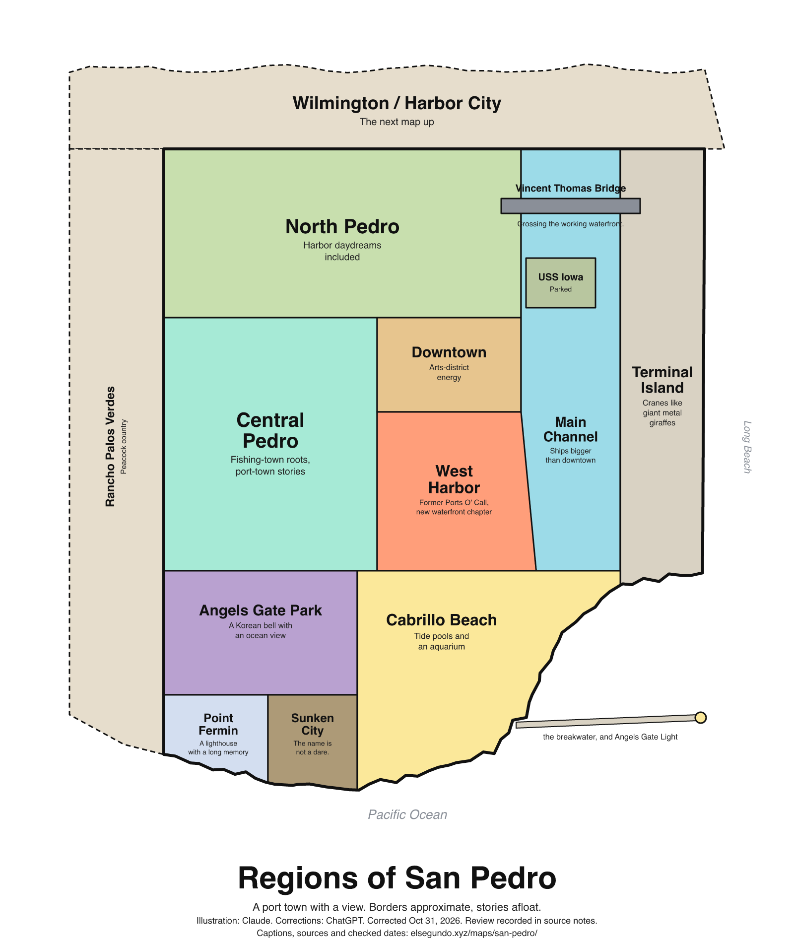
How to read this drawing
A schematic harbor-side grouping: Wilmington and Harbor City sit along the top; Rancho Palos Verdes is the western neighbor; the Main Channel and Terminal Island are east of San Pedro. Downtown and West Harbor occupy the west-channel waterfront. Angels Gate Park, Point Fermin, Sunken City and Cabrillo Beach form the southern coastal group; Angels Gate Light marks the harbor entrance. These drawing regions are editorial groupings, not surveyed neighborhood boundaries, navigation directions or an access map.
Labels are schematic. Use an operator's current map for directions and check current access, hours and conditions before visiting.
Every caption, in readable text
This transcript includes the labels, jokes, neighboring places and title printed in the artwork.
- Wilmington / Harbor City — The next map up
- Rancho Palos Verdes — Peacock country
- North Pedro — Harbor daydreams included
- Central Pedro — Fishing-town roots, port-town stories
- Downtown — Arts-district energy
- West Harbor — Former Ports O’ Call, new waterfront chapter
- Vincent Thomas Bridge
- Crossing the working waterfront.
- USS Iowa — Parked
- Main Channel — Ships bigger than downtown
- Terminal Island — Cranes like giant metal giraffes
- Angels Gate Park — A Korean bell with an ocean view
- Point Fermin — A lighthouse with a long memory
- Sunken City — The name is not a dare.
- Cabrillo Beach — Tide pools and an aquarium
- the breakwater, and Angels Gate Light
- Pacific Ocean
- Long Beach
- Regions of San Pedro
- A port town with a view. Borders approximate, stories afloat.
- Illustration: Claude. Corrections: ChatGPT. Corrected Oct 31, 2026. Review recorded in source notes.
- Captions, sources and checked dates: elsegundo.xyz/maps/san-pedro/
Facts behind the captions
Factual labels and layout notes are documented below. The jokes are editorial wording; they do not establish measurements, operating status or visitor access.
- The Port of Los Angeles places its Main Channel camera in San Pedro and names USS Iowa and Terminal Island among the visible harbor landmarks. This supports the map’s broad harbor grouping, not the exact drawn borders. [sp-port-channel]
- West Harbor identifies its location as the former Ports O’ Call site in San Pedro and describes the downtown waterfront arts district as adjacent. The caption does not promise a construction phase, opening date or visitor access. [sp-west-harbor-site] [sp-downtown-adjacency]
- The waterfront operator’s history describes fishing boats, canneries, shipyards and waterfront workers as part of San Pedro’s roots. The fishing-town caption refers to this citywide heritage. [sp-waterfront-history]
- Dated travel context only: on September 25, 2026, Caltrans announced a planned November 7, 2026 start for a 16-month Vincent Thomas Bridge closure. Checked October 30, 2026 (Los Angeles). This is an agency plan, not confirmation of a future closure or reopening; consult Caltrans for current conditions. The downloadable artwork uses a timeless caption. [sp-bridge-plan]
- Discover Los Angeles places the Korean Friendship Bell inside Angels Gate Park overlooking the Pacific. No ringing schedule or access promise is reproduced. [sp-bell]
- The Point Fermin Lighthouse Society identifies Point Fermin Lighthouse in San Pedro and records its establishment in 1874. The revised caption uses the lighthouse identity without an unverified architectural classification. [sp-point-fermin]
- Cabrillo Marine Aquarium describes neighboring Cabrillo Coastal Park and trails leading to tidepools and beaches. The caption identifies these nearby features without guaranteeing hours, tides, conditions or accessible routes. [sp-cabrillo-coast] [sp-cabrillo-tidepools]
- The Los Angeles Maritime Museum identifies Angels Gate Lighthouse as Los Angeles Harbor Light at the harbor entrance; its museum-director article places the lighthouse at the end of the federal breakwater. [sp-angels-gate-light] [sp-breakwater]
- Rancho Palos Verdes reports conducting a neighborhood peafowl census. “Peacock country” is an editorial shorthand for this documented presence, not a population or wildlife-viewing guarantee. [sp-peafowl]
Port of Los Angeles [sp-port-channel]
Los Angeles Main Channel in San Pedro, featuring views of historic battleship USS Iowa, Wilmington Clock Tower, Everport Container Terminal, Terminal Island
West Harbor / San Pedro Public Market LLC [sp-west-harbor-site]
Developed on the former Ports O’ Call site in San Pedro
West Harbor / San Pedro Public Market LLC [sp-downtown-adjacency]
Adjacent to the San Pedro Historic Downtown Waterfront Arts District
West Harbor / San Pedro Public Market LLC [sp-waterfront-history]
Fishing boats, canneries, shipyards, cargo and generations of waterfront workers shaped the community
Caltrans District 7 [sp-bridge-plan]
16-month closure of the Vincent Thomas Bridge (State Route 47) for Saturday, Nov. 7 at 12:01 a.m.
Los Angeles Tourism & Convention Board / Discover Los Angeles; Liz Ohanesian [sp-bell]
Overlooking the Pacific in San Pedro, inside Angels Gate Park
Point Fermin Lighthouse Society [sp-point-fermin]
Point Fermin Lighthouse, San Pedro California Established December 15, 1874
Cabrillo Marine Aquarium / City of Los Angeles Recreation and Parks [sp-cabrillo-coast]
Cabrillo Coastal Park, located just steps from Cabrillo Marine Aquarium.
Cabrillo Marine Aquarium / City of Los Angeles Recreation and Parks [sp-cabrillo-tidepools]
scenic walking trails leading to tidepools, sandy beaches, and a thriving salt marsh.
Los Angeles Maritime Museum [sp-angels-gate-light]
The Angels Gate Lighthouse (officially known as Los Angeles Harbor Light) has marked the entrance of Los Angeles Harbor
Los Angeles Maritime Museum; Marifrances Trivelli, Director, Channel Crossings (Autumn 2011) [sp-breakwater]
Located at the end of the two-mile federal breakwater
City of Rancho Palos Verdes [sp-peafowl]
an annual count of peacocks and peahens in RPV neighborhoods
About this version
Artwork and initial captions: Claude (Anthropic). Corrections and source notes: ChatGPT/Codex (OpenAI). Checked by: GPT-6 Astra (OpenAI), ChatGPT/Codex (OpenAI; independent geometry review). Publication authorized by Michael Hoydich. Completed review: .
Review scope: Technical source-guide, accessible-transcript and schematic-layout checks. Independent source authentication sampled primary pages and retained official GIS/map records; it did not re-authenticate every source or establish surveyed boundaries or current visitor access.
- Corrected October 31, 2026 (Los Angeles): Removed unsupported bridge-closure timing and waterfront-opening claims. Access and current operating status are not implied by the illustration.
- Added a complete readable transcript, source excerpts with actual fetch dates, and a schematic-layout explanation. Sources do not establish current visitor access, hours or availability.
Captions, sources and provenance as JSON · Report a correction