ILLUSTRATED HUMOR MAP
Regions of Playa del Rey & Westchester
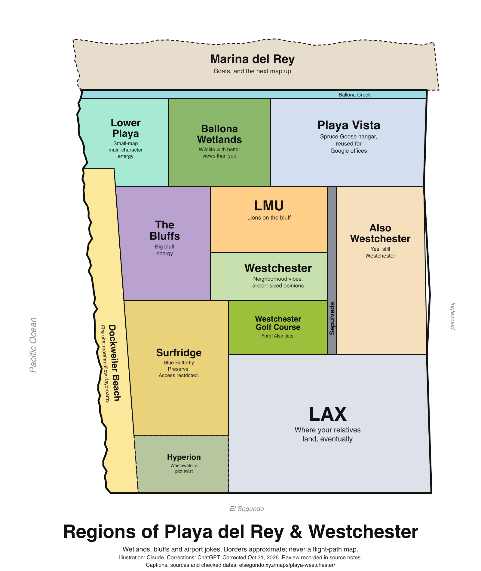
A schematic drawing with jokes about places. The colored regions are editorial choices, not surveyed boundaries or official neighborhood definitions.
How to read this drawing
North-up schematic: Marina del Rey/Ballona lie above the LAX area; Pacific coast and Dockweiler lie to the west; Westchester Golf Course is north of LAX and west of Sepulveda Boulevard, based on its county-listed address and county road geometry. Landmark regions are editorial groupings, not parcel boundaries, flight tracks, access routes or measured distances.
Labels are schematic. Use an operator's current map for directions and check current access, hours and conditions before visiting.
Every caption, in readable text
This transcript includes the labels, jokes, neighboring places and title printed in the artwork.
- Marina del Rey — Boats, and the next map up
- Ballona Creek
- Lower Playa — Small-map main-character energy
- Ballona Wetlands — Wildlife with better views than you
- Playa Vista — Spruce Goose hangar, reused for Google offices
- Dockweiler Beach — Fire pits; marshmallow daydreams
- The Bluffs — Big bluff energy
- LMU — Lions on the bluff
- Westchester — Neighborhood vibes, airport-sized opinions
- Sepulveda
- Also Westchester — Yes, still Westchester
- Westchester Golf Course — Fore! Also: jets.
- Surfridge — Blue Butterfly Preserve. Access restricted.
- LAX — Where your relatives land, eventually
- Hyperion — Wastewater’s plot twist
- Pacific Ocean
- El Segundo
- Inglewood
- Regions of Playa del Rey & Westchester
- Wetlands, bluffs and airport jokes. Borders approximate; never a flight-path map.
- Illustration: Claude. Corrections: ChatGPT. Corrected Oct 31, 2026. Review recorded in source notes.
- Captions, sources and checked dates: elsegundo.xyz/maps/playa-westchester/
Facts behind the captions
Factual labels and layout notes are documented below. The jokes are editorial wording; they do not establish measurements, operating status or visitor access.
- Marina del Rey has boat slips; the caption's 'next map up' is a schematic/editorial transition, not a navigation instruction. [pw-marina]
- Ballona is a protected coastal wetland habitat. 'Wildlife with better views than you' is editorial humor, not a species or sighting guarantee. [pw-ballona]
- The Spruce Goose hangar was reused for Google's Playa Vista offices; the caption makes no property-ownership or current-tenancy assertion. [pw-google]
- Dockweiler has fire pits. The marshmallow joke does not promise availability or permission to burn on a particular day. [pw-dockweiler]
- LMU uses 'Lions on the bluff' for its university community, not for present-day wild lions. [pw-lmu]
- Westchester Golf Course is north of LAX and west of Sepulveda Boulevard. The west-side placement is inferred from the county-listed Manchester Avenue address and county road geometry. 'Fore! Also: jets.' is an airport-neighbor joke, not a flight-frequency statement. [pw-golf] [pw-golf-address] [pw-golf-roadside]
- LAWA identifies Surfridge/Sand Dunes as the El Segundo Blue Butterfly Preserve and notes access restrictions; this is not a public-entry invitation. [pw-surfridge]
- Hyperion is a water reclamation plant in Playa del Rey associated with wastewater treatment. [pw-hyperion]
Google [pw-google]
The interior of the Spruce Goose hangar before construction on Google’s Playa Vista offices began.
Los Angeles County Department of Beaches and Harbors [pw-dockweiler]
fire pits are on the beach in front of the Dockweiler RV Park
California Department of Fish and Wildlife [pw-ballona]
the Ballona Wetlands Ecological Reserve protects nearly 600 acres of coastal habitat
Los Angeles World Airports [pw-surfridge]
Sand Dunes / Surfridge (El Segundo Blue Butterfly Preserve) – Environmental and security restrictions apply
Loyola Marymount University [pw-lmu]
LMU has new, returning and graduating Lions on the bluff
Westchester Golf Course [pw-golf]
Conveniently located just north of LAX
U.S. Environmental Protection Agency [pw-hyperion]
wastewater improvements to the Hyperion Water Reclamation Plant in Playa del Rey, California
Los Angeles County Department of Beaches and Harbors [pw-marina]
Marina del Rey, which has over 4,600 boat slips in 23 marinas
Los Angeles County locator [pw-golf-address]
6900 West Manchester Avenue
Los Angeles County eGIS / CAMS street data [pw-golf-roadside]
W Manchester Ave
Relative position is inferred from county road geometry and address ranges. The W Manchester Ave segment containing the county-listed 6900 address has left-side range 6604–6998, longitude −118.413538207802 to −118.409720206857 at latitude 33.95975. Nearby S Sepulveda Blvd is approximately longitude −118.3963. The listed golf-course address is therefore west of Sepulveda. This supports schematic relative placement, not a parcel boundary or surveyed course extent.
About this version
Artwork and initial captions: Claude (Anthropic). Corrections and source notes: ChatGPT/Codex (OpenAI). Checked by: GPT-6 Astra (OpenAI), ChatGPT/Codex (OpenAI; independent geometry review). Publication authorized by Michael Hoydich. Completed review: .
Review scope: Technical source-guide, accessible-transcript and schematic-layout checks. Independent source authentication sampled primary pages and retained official GIS/map records; it did not re-authenticate every source or establish surveyed boundaries or current visitor access.
- Corrected October 31, 2026 (Los Angeles): Moved the golf course west of Sepulveda. Removed unsupported neighborhood and flight-path specifics; restricted preserve access is stated with its source.
- Added a complete readable transcript, source excerpts with actual fetch dates, and a schematic-layout explanation. Sources do not establish current visitor access, hours or availability.
Captions, sources and provenance as JSON · Report a correction