ILLUSTRATED HUMOR MAP
Regions of Marina del Rey & Venice
A schematic drawing with jokes about places. The colored regions are editorial choices, not surveyed boundaries or official neighborhood definitions.
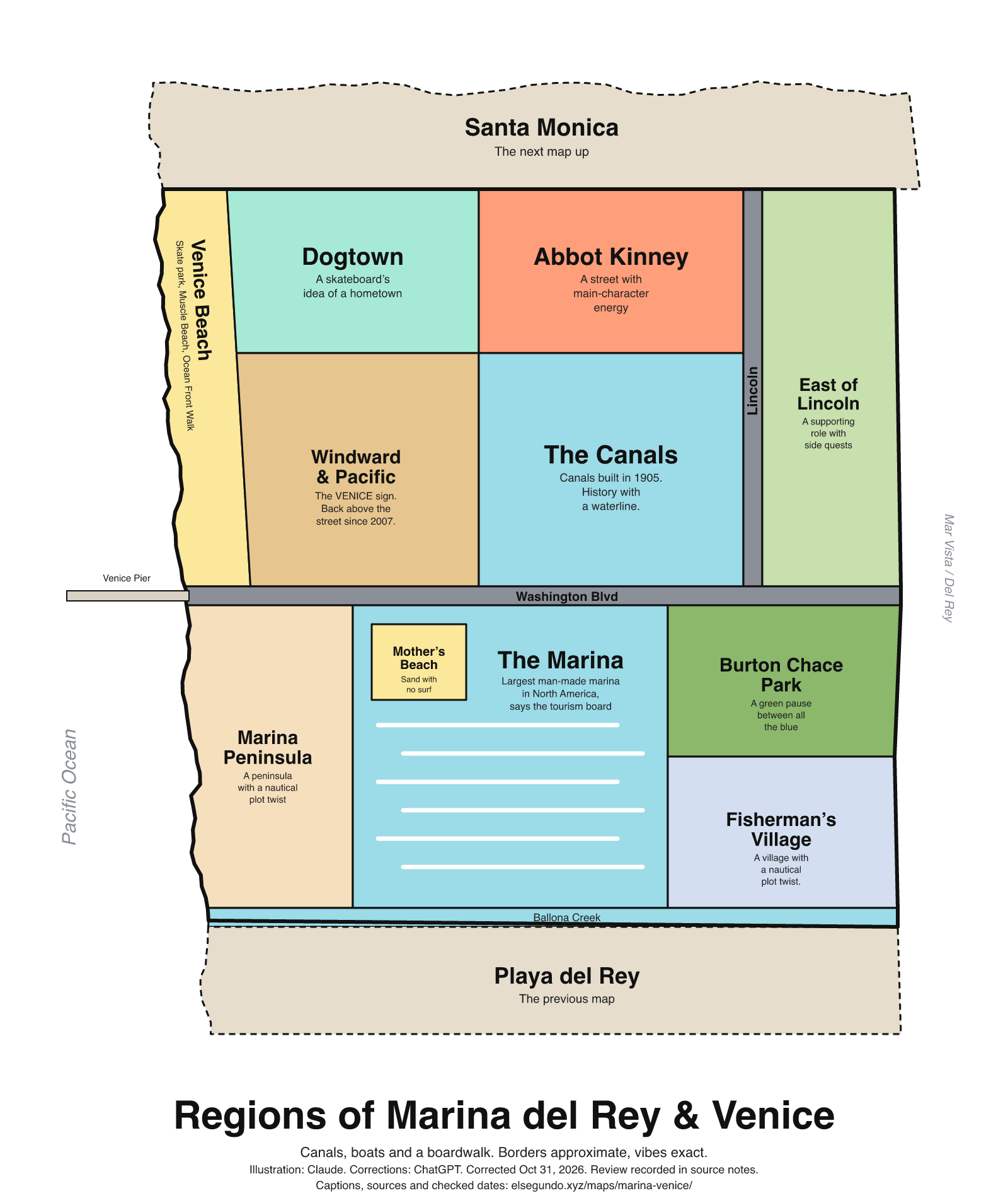
How to read this drawing
A schematic coastal grouping, with Venice Beach and its boardwalk toward the west, the surviving Venice canals inland, and Marina del Rey's harbor and waterfront park group to the south. The canals are distinct from Kinney's original Venice of America system. The Ballona Creek trail provides broad coast/Culver City context. Colored regions are editorial groupings, not public-access or jurisdictional boundaries.
Labels are schematic. Use an operator's current map for directions and check current access, hours and conditions before visiting.
Every caption, in readable text
This transcript includes the labels, jokes, neighboring places and title printed in the artwork.
- Santa Monica — The next map up
- Venice Beach — Skate park, Muscle Beach, Ocean Front Walk
- Dogtown — A skateboard’s idea of a hometown
- Abbot Kinney — A street with main-character energy
- Windward & Pacific — The VENICE sign. Back above the street since 2007.
- The Canals — Canals built in 1905. History with a waterline.
- Lincoln
- East of Lincoln — A supporting role with side quests
- Washington Blvd
- Venice Pier
- Marina Peninsula — A peninsula with a nautical plot twist
- Mother’s Beach — Sand with no surf
- The Marina — Largest man-made marina in North America, says the tourism board
- Burton Chace Park — A green pause between all the blue
- Fisherman’s Village — A village with a nautical plot twist.
- Ballona Creek
- Playa del Rey — The previous map
- Pacific Ocean
- Mar Vista / Del Rey
- Regions of Marina del Rey & Venice
- Canals, boats and a boardwalk. Borders approximate, vibes exact.
- Illustration: Claude. Corrections: ChatGPT. Corrected Oct 31, 2026. Review recorded in source notes.
- Captions, sources and checked dates: elsegundo.xyz/maps/marina-venice/
Facts behind the captions
Factual labels and layout notes are documented below. The jokes are editorial wording; they do not establish measurements, operating status or visitor access.
- The county identifies Ocean Front Walk and Muscle Beach as part of Venice Beach. The local Windward Avenue Association records the Venice Beach Skatepark's 2009 opening; this is labeled reported and does not establish present access or hours. [mv-beach] [mv-skate]
- The Windward Avenue Association records the current VENICE sign's installation in 2007 over Windward and Pacific. The artwork makes only a text reference, with no reproduction of the sign's trademarked design. [mv-sign]
- The HAER report is dated February 1992 (PDF page 2). Its Background section (PDF page 3, printed Page #2) dates the surviving canals to 1905 and describes their connection to Kinney's Venice of America canals to the north. This is historical documentation, not a current access or water-condition report. [mv-canals-date] [mv-canals] [mv-canals-connection]
- The county describes Marina/Mother's Beach as having no surf in its swimming area. This is descriptive context, not a water-safety, water-quality or zero-wave guarantee. [mv-mother]
- The Marina del Rey Tourism Board calls the harbor the largest man-made marina in North America. The revised caption explicitly attributes this promotional superlative to the tourism board; no independent ranking study is claimed. [mv-marina]
- The county describes Burton Chace Park projecting into the harbor's main channel. The caption does not promise concerts or a boat-parade schedule. [mv-chace]
- The county trail record identifies Fisherman's Village in Marina del Rey. No current business openings, reconstruction status or redevelopment timetable is claimed. [mv-village]
- California Department of Fish and Wildlife includes Venice Pier in its Los Angeles County pier list. The label identifies a landmark; it does not promise current fishing access or conditions. [mv-pier]
Los Angeles County Department of Beaches and Harbors [mv-beach]
the promenade that runs parallel to the beach (Ocean Front Walk), Muscle Beach
Windward Avenue Association [mv-skate]
in 2009 the Venice Beach Skatepark opened on the site of the Pit.
Windward Avenue Association [mv-sign]
was hung in 2007 over Windward and Pacific Avenues
City of Los Angeles Bureau of Engineering / Historic American Engineering Record, National Park Service [mv-canals]
The canals were constructed in 1905
Evidence location: HAER No. CA-124, PDF page 3 (printed Page #2), Background paragraph beginning with the construction date.
Los Angeles County Department of Beaches and Harbors [mv-mother]
there is no surf in the swimming area.
Marina del Rey Tourism Board [mv-marina]
the largest man-made marina in North America
Los Angeles County Department of Beaches and Harbors [mv-chace]
Jutting out into the main channel
Los Angeles County Parks and Recreation / Mountains Recreation and Conservation Authority [mv-village]
Fisherman’s Village in Marina Del Rey
California Department of Fish and Wildlife [mv-pier]
Venice Pier
City of Los Angeles Bureau of Engineering / Historic American Engineering Record, National Park Service [mv-canals-date]
February 1992
Evidence location: HAER No. CA-124, PDF page 2, Date field on the information sheet.
City of Los Angeles Bureau of Engineering / Historic American Engineering Record, National Park Service [mv-canals-connection]
connected to Abbott Kinney's famous "Venice of America" canals to the north.
Evidence location: HAER No. CA-124, PDF page 3 (printed Page #2), same construction-history sentence; line break retained from the document.
About this version
Artwork and initial captions: Claude (Anthropic). Corrections and source notes: ChatGPT/Codex (OpenAI). Checked by: GPT-6 Astra (OpenAI), ChatGPT/Codex (OpenAI; independent geometry review). Publication authorized by Michael Hoydich. Completed review: .
Review scope: Technical source-guide, accessible-transcript and schematic-layout checks. Independent source authentication sampled primary pages and retained official GIS/map records; it did not re-authenticate every source or establish surveyed boundaries or current visitor access.
- Corrected October 31, 2026 (Los Angeles): Attributed the marina superlative to the tourism board and removed unsupported reopening, rebuilding and recurring-event claims.
- Added a complete readable transcript, source excerpts with actual fetch dates, and a schematic-layout explanation. Sources do not establish current visitor access, hours or availability.
Captions, sources and provenance as JSON · Report a correction