ILLUSTRATED HUMOR MAP
Regions of Long Beach
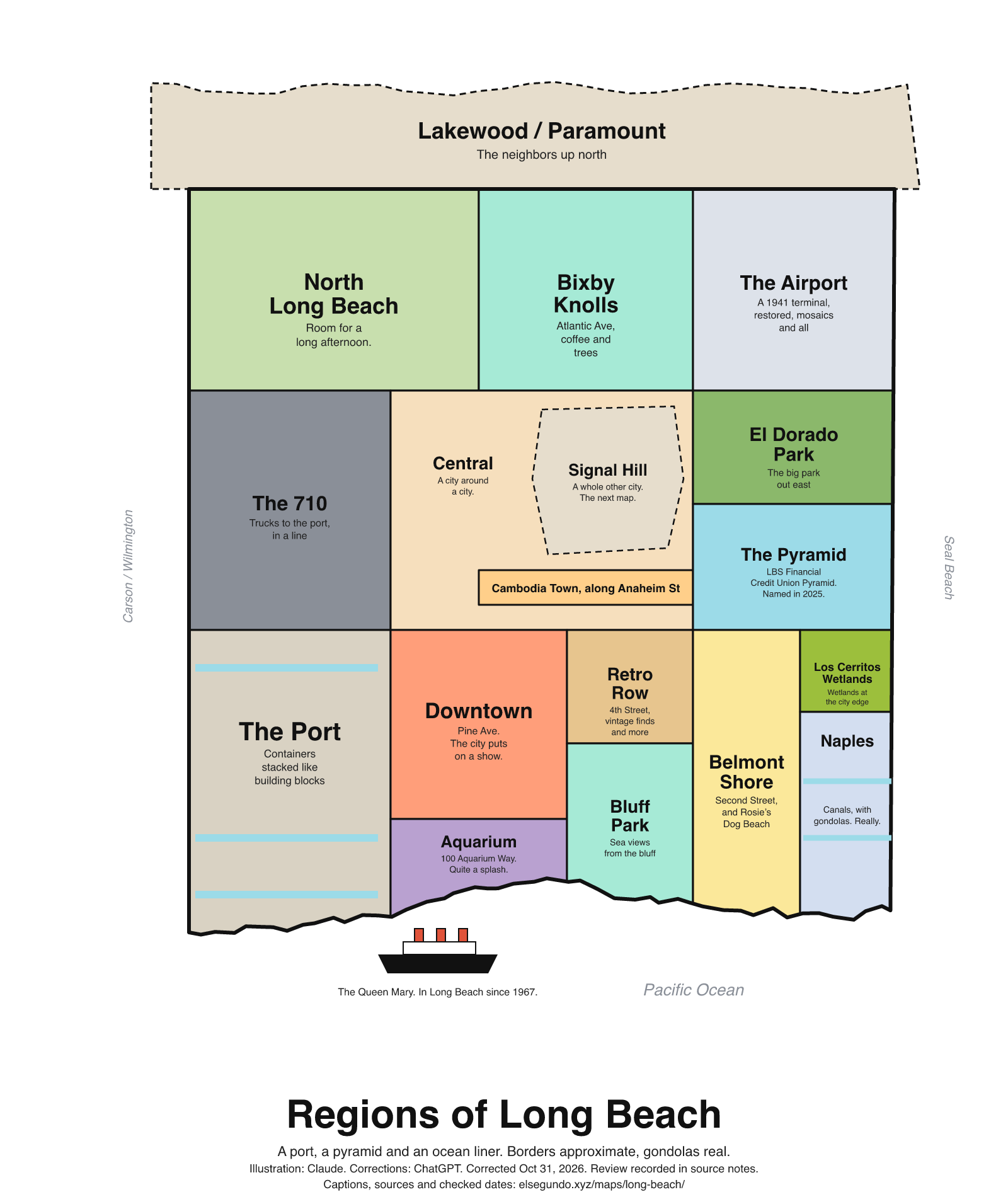
A schematic drawing with jokes about places. The colored regions are editorial choices, not surveyed boundaries or official neighborhood definitions.
How to read this drawing
Editorial coastal-city sketch with the port and downtown toward the waterfront, the airport inland, El Dorado Park in the east, and Signal Hill shown as a separate city surrounded by Long Beach. The wetlands label groups the Los Cerritos Wetlands area near the Long Beach and Seal Beach boundary; it does not show a construction footprint. Neighborhood polygons, highway shapes and the shoreline are schematic rather than navigation or legal boundaries.
Labels are schematic. Use an operator's current map for directions and check current access, hours and conditions before visiting.
Every caption, in readable text
This transcript includes the labels, jokes, neighboring places and title printed in the artwork.
- Lakewood / Paramount — The neighbors up north
- North Long Beach — Room for a long afternoon.
- Bixby Knolls — Atlantic Ave, coffee and trees
- The Airport — A 1941 terminal, restored, mosaics and all
- The 710 — Trucks to the port, in a line
- Signal Hill — A whole other city. The next map.
- Central — A city around a city.
- Cambodia Town, along Anaheim St
- El Dorado Park — The big park out east
- The Pyramid — LBS Financial Credit Union Pyramid. Named in 2025.
- The Port — Containers stacked like building blocks
- Downtown — Pine Ave. The city puts on a show.
- Aquarium — 100 Aquarium Way. Quite a splash.
- Retro Row — 4th Street, vintage finds and more
- Bluff Park — Sea views from the bluff
- Belmont Shore — Second Street, and Rosie’s Dog Beach
- Los Cerritos Wetlands — Wetlands at the city edge
- Naples
- Canals, with
- gondolas. Really.
- The Queen Mary. In Long Beach since 1967.
- Pacific Ocean
- Carson / Wilmington
- Seal Beach
- Regions of Long Beach
- A port, a pyramid and an ocean liner. Borders approximate, gondolas real.
- Illustration: Claude. Corrections: ChatGPT. Corrected Oct 31, 2026. Review recorded in source notes.
- Captions, sources and checked dates: elsegundo.xyz/maps/long-beach/
Facts behind the captions
Factual labels and layout notes are documented below. The jokes are editorial wording; they do not establish measurements, operating status or visitor access.
- Bixby Knolls includes Atlantic Avenue, tree-lined streets and coffeehouses. The caption does not assert the trees’ ages. [lb-bixby-atlantic] [lb-bixby-trees] [lb-bixby-coffee]
- The airport’s historic 1941 terminal design and floor mosaic were restored in the reopening announced July 27, 2024. [lb-airport-1941] [lb-airport-mosaic]
- The 710 corridor carries trucks serving the ports; “in a line” is editorial traffic humor, not live traffic reporting. [lb-710]
- Signal Hill is a separate city surrounded by Long Beach. The map-series reference is internal editorial navigation. [lb-signal-city]
- Cambodia Town is centered along Anaheim Street. [lb-cambodia]
- El Dorado Regional Park is a major park in the East Long Beach destination listing. [lb-el-dorado]
- California State University Long Beach announced the LBS Financial Credit Union Pyramid naming in November 2025. [lb-pyramid]
- The Port of Long Beach is a container port. The building-block comparison is editorial. No current port ranking or cargo count is repeated. [lb-port]
- Pine Avenue is part of the downtown listing. [lb-downtown]
- Aquarium of the Pacific is listed at 100 Aquarium Way, Long Beach. [lb-aquarium]
- Retro Row is along 4th Street with vintage and other shops; the caption no longer implies every item is secondhand. [lb-retro-street] [lb-retro-shops]
- Bluff Park overlooks the Pacific. [lb-bluff]
- Belmont Shore includes Second Street and Rosie’s Dog Beach. No access rules or hours are reproduced. [lb-belmont-second] [lb-rosies]
- Los Cerritos Wetlands lie at the Long Beach and Seal Beach boundary. [lb-wetlands]
- Naples has canals and a listed gondola activity. This is not a promise of availability or a booking offer. [lb-naples]
- The Queen Mary arrived in Long Beach in 1967. This does not assert that it has occupied one exact berth continuously. [lb-queen-mary]
Visit Long Beach [lb-neighborhoods]
Belmont Shore
Visit Long Beach [lb-bixby-atlantic]
with Atlantic Avenue at its heart
Visit Long Beach [lb-bixby-trees]
tree-lined streets
Visit Long Beach [lb-bixby-coffee]
coffeehouses
City of Long Beach [lb-airport-1941]
meticulous restoration of the building’s classic 1941 design elements
City of Long Beach [lb-airport-mosaic]
the uncovering of the full floor mosaic
Los Angeles County Metropolitan Transportation Authority [lb-710]
heavy-duty trucks that serve the ports, railyards, warehouses, logistics centers, and transloading facilities
City of Signal Hill [lb-signal-city]
completely surrounded by the City of Long Beach
Visit Long Beach [lb-cambodia]
Cambodia Town, centered along Anaheim Street between Atlantic and Junipero avenues
Visit Long Beach [lb-el-dorado]
El Dorado Regional Park is a centerpiece
Long Beach State University Athletics [lb-pyramid]
will rename the iconic campus sports and events venue the "LBS Financial Credit Union Pyramid."
City of Long Beach, Port of Long Beach and Long Beach CVB joint release [lb-port]
container seaport
Visit Long Beach [lb-downtown]
Pine Avenue & The Promenade
Visit Long Beach [lb-aquarium]
100 Aquarium Way Long Beach, CA 90802
Visit Long Beach [lb-retro-street]
Located along 4th Street, Retro Row
Visit Long Beach [lb-retro-shops]
vintage clothing, modern fashion, furniture, antiques, collectibles, books, art, records and specialty finds
Visit Long Beach [lb-bluff]
Bluff Park (Ocean Blvd, between 20th and 36th Place) has expansive views of the Pacific
Visit Long Beach [lb-belmont-second]
Belmont Shore is one of Long Beach's signature neighborhoods, and for many visitors, its lively Second Street
Visit Long Beach [lb-rosies]
stretch of sand in Belmont Shore–on Ocean Boulevard between Granada and Roycroft avenues
Los Cerritos Wetlands Authority [lb-wetlands]
located along the San Gabriel River, at the boundary of Long Beach and Seal Beach
Visit Long Beach [lb-naples]
with gondolas gliding through the canals
The Queen Mary [lb-queen-mary]
Arrival in Long Beach | 12/9/1967
About this version
Artwork and initial captions: Claude (Anthropic). Corrections and source notes: ChatGPT/Codex (OpenAI). Checked by: GPT-6 Astra (OpenAI), ChatGPT/Codex (OpenAI; independent geometry review). Publication authorized by Michael Hoydich. Completed review: .
Review scope: Technical source-guide, accessible-transcript and schematic-layout checks. Independent source authentication sampled primary pages and retained official GIS/map records; it did not re-authenticate every source or establish surveyed boundaries or current visitor access.
- Corrected October 31, 2026 (Los Angeles): Replaced unsupported recurring-event and restoration-status assertions with cautious wording and added dated sources for the remaining historical and naming claims.
- Added a complete readable transcript, source excerpts with actual fetch dates, and a schematic-layout explanation. Sources do not establish current visitor access, hours or availability.
Captions, sources and provenance as JSON · Report a correction