ILLUSTRATED HUMOR MAP
Regions of Hawthorne & Lawndale
A schematic drawing with jokes about places. The colored regions are editorial choices, not surveyed boundaries or official neighborhood definitions.
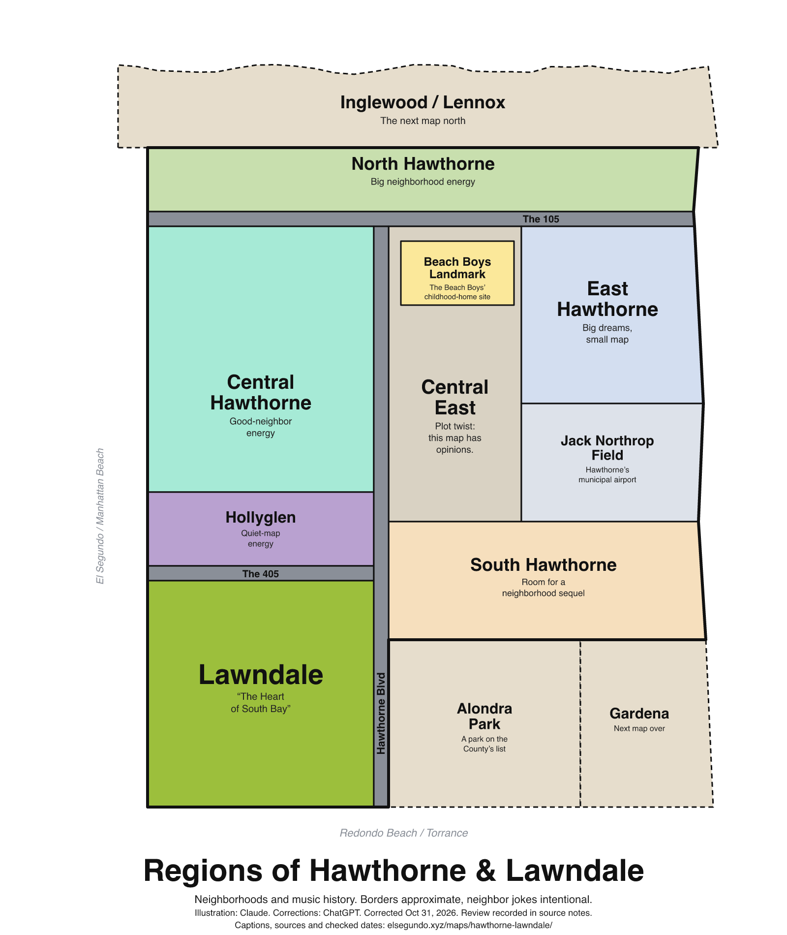
How to read this drawing
North-up schematic grouping of Hawthorne and Lawndale. A municipal community description places Inglewood/Lennox to Hawthorne's north, Lawndale south, El Segundo west and Gardena east. Hawthorne Police names Hollyglen, Bodger Park and Moneta Gardens in its neighborhood-group directory. The Beach Boys landmark's 3701 W. 119th Street address lies east of Hawthorne Boulevard according to County road ranges. Exact road lines and neighborhood outlines remain illustrative.
Labels are schematic. Use an operator's current map for directions and check current access, hours and conditions before visiting.
Every caption, in readable text
This transcript includes the labels, jokes, neighboring places and title printed in the artwork.
- Inglewood / Lennox — The next map north
- North Hawthorne — Big neighborhood energy
- The 105
- Beach Boys Landmark — The Beach Boys’ childhood-home site
- Central Hawthorne — Good-neighbor energy
- Central East — Plot twist: this map has opinions.
- East Hawthorne — Big dreams, small map
- Jack Northrop Field — Hawthorne’s municipal airport
- Hollyglen — Quiet-map energy
- The 405
- Hawthorne Blvd
- South Hawthorne — Room for a neighborhood sequel
- Lawndale — “The Heart of South Bay”
- Alondra Park — A park on the County’s list
- Gardena — Next map over
- El Segundo / Manhattan Beach
- Redondo Beach / Torrance
- Regions of Hawthorne & Lawndale
- Neighborhoods and music history. Borders approximate, neighbor jokes intentional.
- Illustration: Claude. Corrections: ChatGPT. Corrected Oct 31, 2026. Review recorded in source notes.
- Captions, sources and checked dates: elsegundo.xyz/maps/hawthorne-lawndale/
Facts behind the captions
Factual labels and layout notes are documented below. The jokes are editorial wording; they do not establish measurements, operating status or visitor access.
- The Beach Boys landmark identifies the site of the childhood home of the Beach Boys; the State lists 3701 W. 119th Street in Hawthorne. [hl-beach-boys] [hl-beach-boys-location]
- Lawndale's website uses the motto 'The Heart of South Bay'. [hl-lawndale]
- Hawthorne Municipal Airport is also called Jack Northrop Field. The caption does not make a current aircraft, tenant or service claim. [hl-airport]
- Los Angeles County lists Alondra Community Regional Park at 3850 Manhattan Beach Boulevard, Lawndale. Postal addressing alone is not a city-boundary determination. [hl-alondra]
- The municipal document's About Our Community paragraph places Lawndale south, El Segundo west, Inglewood and Lennox north, and Gardena east of Hawthorne. This is a historical municipal description of general relationships, not current boundary certification; its demographic or property-development claims are not reproduced. [hl-neighbors]
- Hawthorne Police's neighborhood-group directory explicitly names Hollyglen, Bodger Park and Moneta Gardens. These labels do not reproduce association boundaries or promise anything about crime, safety, housing or noise. [hl-neighborhoods] [hl-neighborhoods-bodger] [hl-neighborhoods-moneta]
- GIS interpretation: the W. 119th Street range containing 3701 lies between longitudes −118.339546 and −118.337381, east of Hawthorne Boulevard near −118.352590 at 119th Street. Combined with the State's landmark address, this supports placing the Beach Boys landmark east of Hawthorne Boulevard. It does not identify an exact parcel entrance. [hl-beach-boys-location] [hl-roads-gis]
California Office of Historic Preservation / California State Parks [hl-beach-boys]
SITE OF THE CHILDHOOD HOME OF THE BEACH BOYS
City of Lawndale [hl-lawndale]
The Heart of South Bay
Los Angeles County [hl-airport]
Also known as Jack Northrop Field
Los Angeles County Department of Parks and Recreation [hl-alondra]
3850 Manhattan Beach Blvd. Lawndale, CA 90260
California Office of Historic Preservation / California State Parks [hl-beach-boys-location]
3701 W. 119th Street, Hawthorne
City of Hawthorne, City Council agenda bill 26 and attached draft RFP [hl-neighbors]
Lawndale to the south, El Segundo to the west, Inglewood and […] Lennox to the north, and Gardena to the east.
Evidence location: PDF page 7 (printed page 4), About Our Community; […] marks omitted words.
Hawthorne Police Department [hl-neighborhoods]
Hollyglen
Hawthorne Police Department [hl-neighborhoods-bodger]
Bodger Park
Hawthorne Police Department [hl-neighborhoods-moneta]
Moneta Gardens
Los Angeles County eGIS, Addressing ROAD_LINES [hl-roads-gis]
W 119th St
About this version
Artwork and initial captions: Claude (Anthropic). Corrections and source notes: ChatGPT/Codex (OpenAI). Checked by: GPT-6 Astra (OpenAI), ChatGPT/Codex (OpenAI; independent geometry review). Publication authorized by Michael Hoydich. Completed review: .
Review scope: Technical source-guide, accessible-transcript and schematic-layout checks. Independent source authentication sampled primary pages and retained official GIS/map records; it did not re-authenticate every source or establish surveyed boundaries or current visitor access.
- Corrected October 31, 2026 (Los Angeles): Moved the Beach Boys landmark east of Hawthorne Boulevard. Removed unsupported mall-demolition and rocket-manufacturing assertions.
- Added a complete readable transcript, source excerpts with actual fetch dates, and a schematic-layout explanation. Sources do not establish current visitor access, hours or availability.
Captions, sources and provenance as JSON · Report a correction