ILLUSTRATED HUMOR MAP
Regions of Gardena
A schematic drawing with jokes about places. The colored regions are editorial choices, not surveyed boundaries or official neighborhood definitions.
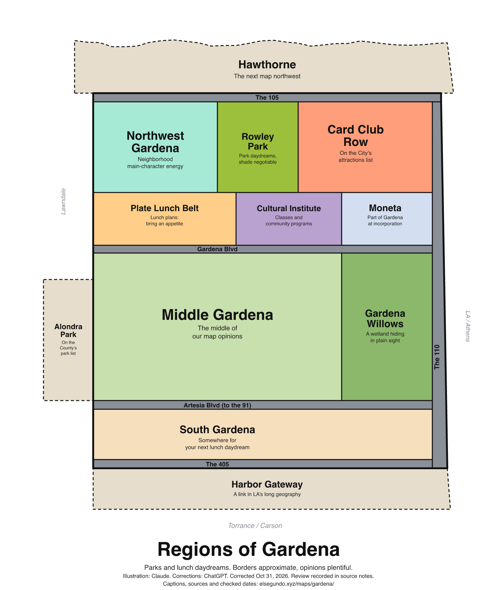
How to read this drawing
North-up schematic: the City's jurisdictional map places Hawthorne northwest, Torrance west/southwest, and Los Angeles areas east and south of Gardena. Artesia Boulevard crosses the illustrated lower corridor toward State Route 91; I-110 is the eastern freeway context and I-405 the southwestern context. Rowley Park is anchored by the City's Van Ness Avenue listing; Alondra is a neighboring County-listed park. Northwest Gardena is a directional label. Illustrative zones are not neighborhood boundaries or precise road alignments.
Labels are schematic. Use an operator's current map for directions and check current access, hours and conditions before visiting.
Every caption, in readable text
This transcript includes the labels, jokes, neighboring places and title printed in the artwork.
- Hawthorne — The next map northwest
- The 105
- Northwest Gardena — Neighborhood main-character energy
- Rowley Park — Park daydreams, shade negotiable
- Card Club Row — On the City’s attractions list
- Plate Lunch Belt — Lunch plans: bring an appetite
- Cultural Institute — Classes and community programs
- Moneta — Part of Gardena at incorporation
- Gardena Blvd
- Middle Gardena — The middle of our map opinions
- Gardena Willows — A wetland hiding in plain sight
- Artesia Blvd (to the 91)
- South Gardena — Somewhere for your next lunch daydream
- The 405
- The 110
- Alondra Park — On the County’s park list
- Harbor Gateway — A link in LA’s long geography
- Lawndale
- Torrance / Carson
- LA / Athens
- Regions of Gardena
- Parks and lunch daydreams. Borders approximate, opinions plentiful.
- Illustration: Claude. Corrections: ChatGPT. Corrected Oct 31, 2026. Review recorded in source notes.
- Captions, sources and checked dates: elsegundo.xyz/maps/gardena/
Facts behind the captions
Factual labels and layout notes are documented below. The jokes are editorial wording; they do not establish measurements, operating status or visitor access.
- Moneta was one of the rural communities combined when Gardena incorporated; the new caption describes the incorporation relationship without portraying an absorption. [g-history]
- The City's attractions page lists a casino; the map's 'Card Club Row' is an editorial grouping, not an official district or an October 2026 open-business count. [g-card-list]
- The Gardena Valley Japanese Cultural Institute describes classes and programs on its own site. [g-jci]
- Gardena Willows is a wetland preserve. 'Hiding in plain sight' is editorial humor, not an entry recommendation. [g-willows]
- The City lists Rowley Park at 13220 S. Van Ness Avenue; the updated caption makes no recurring soccer-event or shade guarantee. [g-rowley]
- Alondra Community Regional Park appears in the County's location listing. [g-alondra]
- Harbor Gateway connects parts of Los Angeles; the caption's 'long geography' is editorial wording for that stated role. [g-harbor]
- Visual interpretation of the City's one-page jurisdictional map: Hawthorne occupies the northwest neighboring area, Torrance the west/southwest, and Los Angeles areas the east and south. The map labels Artesia Boulevard through the lower Gardena corridor, I-110 on the east, and I-405 southwest. The original continuous 'The 91' band is consequently relabeled Artesia Boulevard; the schematic does not identify the precise legal route-transition point. [g-jurisdictional-map]
- County road features identify Artesia Boulevard across the examined Gardena corridor, including 1500- and 3100-block segments. The 'to the 91' wording gives broad eastward regional context, not an assertion that the entire illustrated band is a freeway. [g-artesia-gis] [g-jurisdictional-map]
- Northwest Gardena is a directional editorial zone consistent with the City's jurisdictional map. It replaces the unverified Hollypark neighborhood assertion. [g-jurisdictional-map]
City of Gardena [g-history]
It combined the rural communities of Gardena, Moneta, and Strawberry Park
City of Gardena [g-card-list]
Hustler Casino
Gardena Valley Japanese Cultural Institute [g-jci]
GVJCI has programs and classes for all ages!
City of Gardena [g-willows]
the Gardena Willows Wetland Preserve’s unique ecosystem
City of Gardena [g-rowley]
Rowley Park – 13220 S. Van Ness Avenue
Los Angeles County Department of Parks and Recreation [g-alondra]
3850 Manhattan Beach Blvd. Lawndale, CA 90260
Los Angeles City Planning [g-harbor]
Harbor Gateway plays an important role by connecting the City of Los Angeles.
City of Gardena [g-jurisdictional-map]
W ARTESIA BLVD
Los Angeles County eGIS, Addressing ROAD_LINES [g-artesia-gis]
W Artesia Blvd
About this version
Artwork and initial captions: Claude (Anthropic). Corrections and source notes: ChatGPT/Codex (OpenAI). Checked by: GPT-6 Astra (OpenAI), ChatGPT/Codex (OpenAI; independent geometry review). Publication authorized by Michael Hoydich. Completed review: .
Review scope: Technical source-guide, accessible-transcript and schematic-layout checks. Independent source authentication sampled primary pages and retained official GIS/map records; it did not re-authenticate every source or establish surveyed boundaries or current visitor access.
- Corrected October 31, 2026 (Los Angeles): Relabeled the road band as Artesia Boulevard toward the 91 and replaced the unsupported Hollypark extent with Northwest Gardena. Removed unsupported count and operating-status claims.
- Added a complete readable transcript, source excerpts with actual fetch dates, and a schematic-layout explanation. Sources do not establish current visitor access, hours or availability.
Captions, sources and provenance as JSON · Report a correction