ILLUSTRATED HUMOR MAP
Regions of Carson
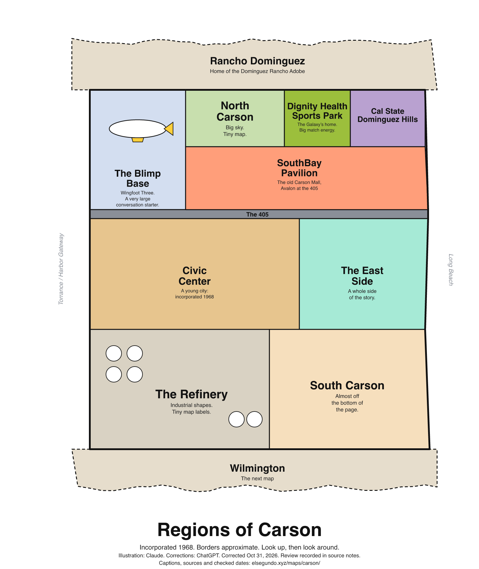
A schematic drawing with jokes about places. The colored regions are editorial choices, not surveyed boundaries or official neighborhood definitions.
How to read this drawing
Illustrative north-up groupings, not surveyed neighborhoods. SouthBay Pavilion is drawn north of I-405, following the broad relationship visible in the city’s Route B map. The university’s sports grounds are grouped west of the academic campus, following the campus map’s orientation. The labeled Dignity Health Sports Park region represents the sports complex; it is not a main-stadium footprint. Operator listings identify the blimp base, university/sports park, City Hall, Adobe and refinery. The Adobe’s Rancho Dominguez mailing address is not evidence of a municipal boundary.
Labels are schematic. Use an operator's current map for directions and check current access, hours and conditions before visiting.
Every caption, in readable text
This transcript includes the labels, jokes, neighboring places and title printed in the artwork.
- Rancho Dominguez — Home of the Dominguez Rancho Adobe
- The Blimp Base — Wingfoot Three. A very large conversation starter.
- North Carson — Big sky. Tiny map.
- Cal State Dominguez Hills
- Dignity Health Sports Park — The Galaxy’s home. Big match energy.
- The 405
- Civic Center — A young city: incorporated 1968
- SouthBay Pavilion — The old Carson Mall, Avalon at the 405
- The East Side — A whole side of the story.
- The Refinery — Industrial shapes. Tiny map labels.
- South Carson — Almost off the bottom of the page.
- Wilmington — The next map
- Torrance / Harbor Gateway
- Long Beach
- Regions of Carson
- Incorporated 1968. Borders approximate. Look up, then look around.
- Illustration: Claude. Corrections: ChatGPT. Corrected Oct 31, 2026. Review recorded in source notes.
- Captions, sources and checked dates: elsegundo.xyz/maps/carson/
Facts behind the captions
Factual labels and layout notes are documented below. The jokes are editorial wording; they do not establish measurements, operating status or visitor access.
- Carson incorporated in 1968; the city history gives February 20, 1968. [carson-incorporation]
- Carson City Hall is listed at 701 East Carson Street, supporting the Civic Center grouping. [carson-city-hall]
- The Dominguez Rancho Adobe Museum lists its location as Rancho Dominguez; no city-line claim is made. [carson-adobe]
- Goodyear identifies its Carson base and Wingfoot Three in the current-fleet description. This identifies the base aircraft and does not promise a sighting or visitor access. [carson-blimp-base] [carson-wingfoot-three]
- Dignity Health Sports Park is home to the LA Galaxy and is on the CSUDH campus in Carson. [carson-galaxy] [carson-stadium-campus]
- Map interpretation: Visual interpretation of the university map (PDF page 1): the labeled soccer grounds are west of the main academic buildings. The schematic preserves this broad relationship; this source alone does not locate the main LA Galaxy stadium footprint. [carson-campus-map]
- Map interpretation: Visual interpretation of the city’s Route B map (PDF page 1): the SB Pavilion label sits on Avalon north of its I-405 crossing. This is a stable-place/road comparison, not a statement about current bus routing. [carson-pavilion-position]
- A city redevelopment plan adopted in 2000 identifies Carson Mall as the earlier name of South Bay Pavilion. [carson-pavilion-history]
- Marathon identifies a Carson facility of its Los Angeles Refinery at East 223rd Street. No employer ranking is supported. [carson-refinery]
City of Carson [carson-incorporation]
Incorporated as a general law city on February 20, 1968
City of Carson [carson-city-hall]
701 East Carson Street
Dominguez Rancho Adobe Museum [carson-adobe]
18127 South Alameda Street Rancho Dominguez*, CA 90220 USA
Goodyear [carson-blimp-base]
Carson - California Base
Goodyear [carson-wingfoot-three]
with the current Wingfoot Three
Dignity Health Sports Park [carson-galaxy]
home of Major League Soccer’s LA Galaxy
Dignity Health Sports Park [carson-stadium-campus]
located on the campus of California State University, Dominguez Hills in Carson, California.
California State University, Dominguez Hills [carson-campus-map]
SOCCER FIELDS
Evidence location: PDF page 1 (the only page): SOCCER FIELDS label, UNIVERSITY DRIVE and VICTORIA STREET labels, and upward north arrow.
Visual interpretation of the map: the labeled sports grounds are west of the academic building cluster. The main LA Galaxy stadium footprint is not clearly shown. “Updated 08/2026” is a printed update month, not a known publication day.
City of Carson [carson-pavilion-position]
SB Pavilion
Evidence location: PDF page 1 (the only page): SB Pavilion label on Avalon above the I-405 crossing, with the north arrow.
Visual interpretation of the named-place and road relationship. The printed August 2, 2021 timestamp is an export date; publication date and current bus service are not established.
Carson Redevelopment Agency [carson-pavilion-history]
Carson Mall and Radisson Hotel (now South Bay Pavilion and Hilton Hotel, respectively)
Document adoption date: . This is separate from publication.
Evidence location: Municipal document heading marked Adopted; document text names Carson Mall and its later South Bay Pavilion name.
August 1, 2000 is the municipal document adoption date, not a verified publication date. The historical naming statement does not establish current mall operations.
Marathon Petroleum [carson-refinery]
Carson: 2350 East 223rd Street, Carson, CA 90810
About this version
Artwork and initial captions: Claude (Anthropic). Corrections and source notes: ChatGPT/Codex (OpenAI). Checked by: GPT-6 Astra (OpenAI), ChatGPT/Codex (OpenAI; independent geometry review). Publication authorized by Michael Hoydich. Completed review: .
Review scope: Technical source-guide, accessible-transcript and schematic-layout checks. Independent source authentication sampled primary pages and retained official GIS/map records; it did not re-authenticate every source or establish surveyed boundaries or current visitor access.
- Corrected October 31, 2026 (Los Angeles): Moved the sports-complex grouping west of the academic campus and SouthBay Pavilion north of I-405. Removed the unsupported largest-employer ranking and clarified that the sports grouping is not a stadium footprint.
- Added a complete readable transcript, source excerpts with actual fetch dates, and a schematic-layout explanation. Sources do not establish current visitor access, hours or availability.
Captions, sources and provenance as JSON · Report a correction